Imagine watching your backyard disappear 2 to 3 feet every year. Such is the case along the 76.6 miles of Lake Erie shoreline where some of the coastal bluffs are receding rapidly. Although increased lake levels over the last few decades may have sped up the loss, erosion of these bluffs is a natural occurrence and will ultimately occur without human influences. However, it’s the unnatural, man-made occurrences, that are playing key roles in speeding up this recession.
What is Bluff Recession?
To understand what bluff recession is, you first must know what a bluff is. Bluffs along Lake Erie are high banks or bold headlands with a broad precipitous cliff face overlooking the lake. Bluffs along the Lake Erie shoreline range anywhere between 5 and 180 feet above lake level.
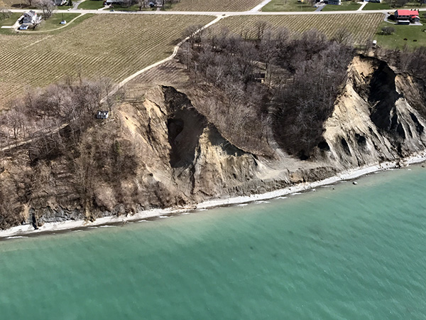
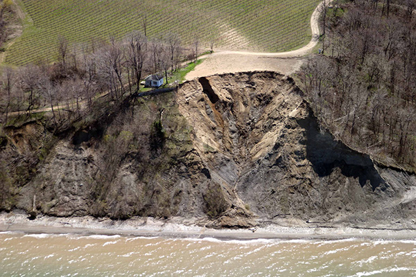
Bluff recession refers to the loss of material along the bluff face caused by natural occurrences such as groundwater seepage, high water levels, water currents, waves, wind, rain, melting snow, freezing, and gravity. The flow of groundwater and surface water runoff can also contribute to bluff recession. This type of recession is expected and occurs daily. However, factors created by humans such as stormwater runoff, wastewater management, and land development are adding to the increased rate of recession. For instance, construction and excavation along the bluffs may involve removing deeply rooted trees and other vegetation along the bluff. As a result, there has been more groundwater and surface water runoff, making the bluffs less stable. This lack of stability can lead to property damage, endanger public safety, and degrade environmental quality along Lake Erie’s shoreline. Although many people have attempted to stabilize the bluff by dumping clean fill or woody debris over the bluff crest, this, in fact, quickly destabilizes the bluff and can lead to rapid, even catastrophic erosion events as the faces of these bluffs are very fragile.
Managing Bluff Recession?
The Pennsylvania Department of Environmental Protection’s (DEP) Coastal Resources Management Program (CRMP) oversees implementation of the Bluff Recession and Setback Program along Lake Erie through technical assistance and oversight of municipal enforcement. To help municipalities and property owners minimize or slow down bluff recession along the Lake Erie coast, the CRMP:
- Requires municipalities with bluff recession hazard areas along the Lake Erie shoreline to enact setback ordinances affecting stationary structures; Provides guidance to the municipalities to assure consistent and coordinated enforcement of the Bluff Recession Setback Act.
- Regulates the siting of any water obstruction or encroachments along Lake Erie to prevent unreasonable interference with water flow and to protect navigation.
- Assists Erie County and affected coastal municipalities in the preparation and implementation of stormwater management plans by assisting them in updating or amending codes, regulations, and ordinances to regulate development in such a manner as to mitigate the adverse impacts to Lake Erie bluffs due to increased rates of stormwater runoff.
- Provides technical assistance and advice concerning the design of methods for shore protection and bluff stabilization; Supports scientific research on shore protection, recession rates, littoral transport, and other aspects of the coastal environment of Lake Erie.
- Assists and helps ensure that identified flood prone coastal municipalities develop state approved floodplain management regulations; Regulates the construction of or substantial improvement to various types of structures and obstructions in the designated floodplains.
Tracking the Bluff’s recession
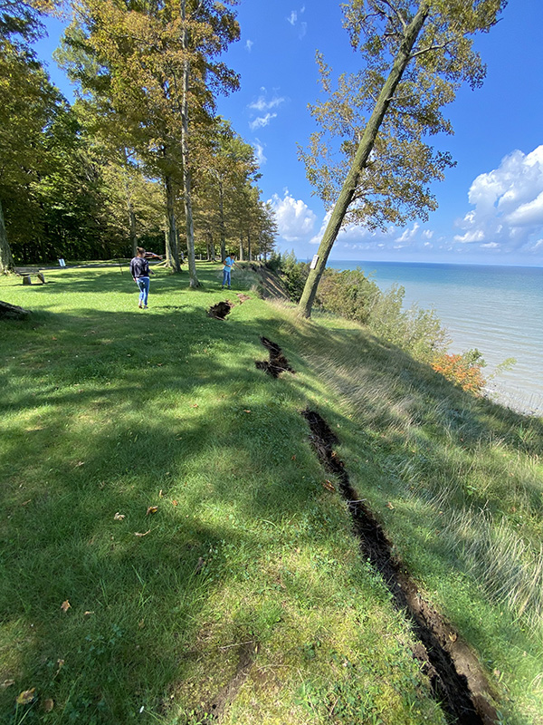
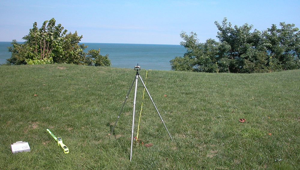
Arguably one of the most import jobs the CRMP has is identifying Bluff Recession Hazard Areas. These are areas or zones where the rate of progressive bluff recession creates a substantial threat to the safety or stability of nearby existing or future structures or utility facilities. In the early 1980s, a control point monitoring program was developed to estimate erosion rates along Pennsylvania’s Lake Erie shoreline. A control point is a fixed marker, such as a buried steel pin or existing utility pole, from which a direct measurement to the bluff crest is made. The control points are located approximately every one-half kilometer along the bluff crest from the Ohio to the New York borders. Direct measurements from the control points to the bluff crest are taken approximately every four years. Data from control point monitoring along with remote sensing technologies like Lidar and aerial photography enables the CRMP to establish an average rate of recession. This data and much more can be found online in the Pennsylvania Lake Erie Control Point Bluff Erosion StoryMap.
Recession Varies Along Coast
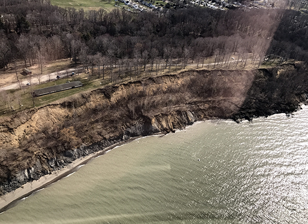
While data shows the entire 76.6 miles of the Lake Erie coastline has experienced significant bluff recession, certain areas have been hit harder than the rest. On average, most control points monitored by the CRMP show a yearly recession rate of five inches per year. However, in places like North East in the very eastern portion of Erie County and Girard and Springfield Townships in the very western portion of Erie County, yearly recession rates have ranged well over a foot or more. One such area is the Lake Erie Community Park, Girard Township, where bluffs are experiencing more recent accelerated rates of erosion. Bluffs in this area are very prone to slumping/slides due to the presence of thick beach and lacustrine (lake) sands near the bluff crest. Bedrock is not exposed at the bluff base at this site, and instead more easily erodible till forms a fragile bluff toe. High lake levels beginning in 2015 and peaking in 2019 have resulted in dramatic recession events across all of Lake Erie. Likewise, in areas of North East, similar effects are occurring. Bluffs located here are composed of a massive top layer of sand and gravel, underlain by finer lacustrine (lake) sands. Next, a layer of clay comprises the base of the bluff. The underlying shale bedrock dips below the water level at this location, allowing for additional wave erosion of these unconsolidated glacial deposits, called till. Recession at this site has been active for decades as wave action erodes soft sediments at the bluff, while surface and groundwater, combined with wind, destabilizes the upper bluff face. This retreat is likely to continue until the bluff reattains an angle of repose with a new landward bluff crest.
What Can Landowners do to Protect the Bluffs?
CRMP, municipalities, and the Erie County Department of Planning and Community Development provide technical assistance to individual property owners to promote best management practices that can minimize bluff recession and educate those property owners on the regulatory requirements. CRMP staff provide free desktop or onsite analyses for individual property owners. CRMP also hosts annual workshops for landowners, realtors, municipal officials, and other individuals operating or living on the shoreline. Topics range from best management practices for property owners, to the effects of high lake levels on shoreline stability and permitting requirements for shoreline structures. Workshops are free and open to the public.
If you would like more information on workshops, have erosion issues, or other concerns, please contact:
Shelby Clark, Lake Erie Coastal Resources Coordinator, 724.953.6006, shelclark@pa.gov