Coastal Zone Aerial Photography
The CRM Program maintains and distributes a library of digital aerial photographs. In the recent years, the program has acquired aerial imagery annually in both coastal zones. Three different types of data products are available, including:
- High-altitude Overhead (or straight-down) Aerial Photography (AP) - Each frame covers a wider area of land, showing less detail on the ground. High-altitude shows the entire coastal zone boundary.
- Low-altitude Overhead AP - Each frame covers a smaller area, but is very detailed. Low-altitude covers only shoreline areas and does not extend significantly inland.
- Oblique Photography - Images of the shoreline are captured at a diagonally-downward angle. The most recent oblique imagery is available for download below.
Digital files are available on a request basis and may take time to complete. To request imagery, please e-mail J. Samantha Burton at jenburton@pa.gov. The following files are available:
- Lake Erie Coastal Zone - High-altitude overhead (1990, 1996, 2005, 2007, 2009, 2011, 2013), Low-altitude overhead (1978, 2000, 2002, 2004, 2006, 2008, 2010, 2012), Obliques (1994, 2004, 2006, 2007, 2008, 2009, 2011 Spring, 2011 Fall, 2013, 2015, 2017)
- Delaware Estuary Coastal Zone - High-altitude overhead (2004, 2006, 2008, 2010 orthophotos, 2012) Low-altitude overhead (2005, 2007, 2009, 2011, 2013) Obliques (2008, 2011, 2012, 2014, 2016)
Oblique Photography Download
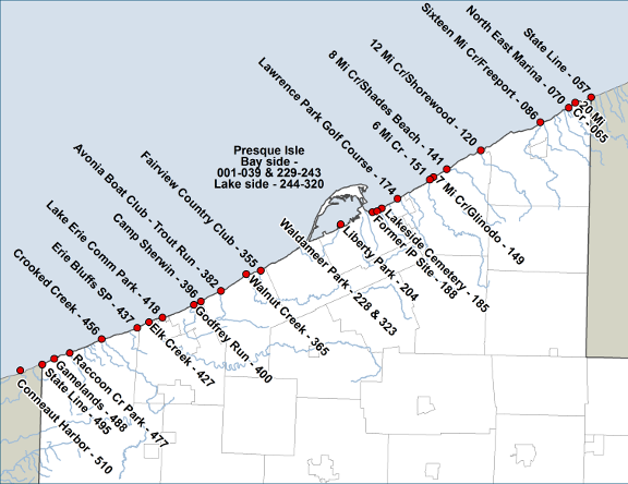
Here you can download JPEGs of our most recent oblique aerial photography. Each digital photograph is named with a sequential number. The reference maps below depict selected landmarks and the corresponding oblique photograph number.
LECZ 2017 Oblique Photography
Flown on 4/8/2017
Click an underlined link below to download a zipped file containing a sequential group of 100 oblique photographs.
Photo
#001-100
#001-039 – Presque Isle (Bay side)
#040 - NY
#057 - PA/NY State Line
#065 - 20 Mile Creek
#070 - North East Marina
#086 - 16 Mile Creek/Freeport |
Photo
#301-400
#244-320 - Presque Isle (Lake side)
#228 - Waldameer Park
#355 - Fairview Country Club
#365 - Walnut Creek
#382 - Avonia Boat Club/Trout Run
#396 - Camp Sherwin
#400 - Godfrey Run |
Photo
#101-200
#120 - 12 Mile Creek/Shorewood
#141 - 8 Mile Creek/Shades Beach
#149 - 7 Mile Creek/Glinodo
#151 - 6 Mile Creek
#174 - Lawrence Park Golf Course
#185 - Lakeside Cemetery
#188 - Former IP Site |
Photo
#401-500
#418 - Lake Erie Community Park
#427 - Elk Creek
#437 - Erie Bluffs State Park
#456 - Crooked Creek
#477 - Raccoon Creek Park
#488 - State Gamelands #314
#495 - PA/OH State Line |
|
Photo
#201-300
#204 - Liberty Park
#228 - Waldameer Park
#229-243 - Presque Isle (Bay side)
#244-320 - Presque Isle (Lake side) |
Photo
#501-597
#510 - Conneaut Harbor
#581 - OH |
DECZ Oblique Photography
Flown on 3/30/2016
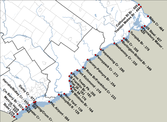
Click an underlined link below to download a zipped file containing a sequential group of 100 oblique photographs
Photo
#001-100
#010 - PA/DE State Line
#020 - Marcus Hook Creek
#037 - Commodore Barry Bridge
#048 - Chester Creek
#055 - Harrahs Casino/ Ridley Creek
#068 - Boeing/Crum Creek
#073 - Darby Creek
#084 - Philadelphia Intl Airport
|
Photo
#301-400
#330 - Neshaminy Creek
#349 - Burlington-Bristol Bridge
#358 - Mill Creek
#378 - Turnpike Bridge
|
|
Photo
#101-200
#129 - Schuylkill River
#139 - Navy Yard
#164 - Walt Whitman Bridge
#170 - Pier 84
#183 - Pier 38
#193 - Ben Franklin Bridge
#200 - Penn Treaty Park
|
Photo
#401-500
#420 - Pennsbury Manor
#427 - US Steel
#464 - Biles Cr
#494 - Trenton Makes Bridge
|
Photo
#201-300
#218 - Port Richmond
#233 - Betsy Ross Bridge/Frankford Cr
#254 - Tacony-Palmyra Bridge
#273
- Pennypack Creek
#290 - Poquessing Creek
|
Photo
#501-574
#505 - Calhoun St Bridge
#549 - I-95 Bridge
#574 - Washington Crossing, PA
|
Schuylkill River Oblique Photography
Flown on 3/30/2016
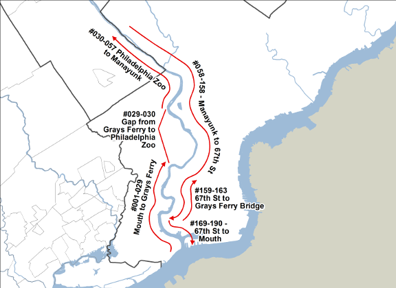
Click an underlined link below
to download a zipped file containing a sequential group of oblique photographs
|
Photo
#001-057 (West Bank flying upstream)
#001-029 - Mouth to Grays Ferry
(Gap from Grays Ferry to Philadelphia Zoo). May be reflown in Summer 2016.
#030-057 - Philadelphia Zoo to Manayunk (northernmost point)
|
Photo
#159-190 (East bank upstream & downstream)
#159-163 - 67th St to Grays Ferry Bridge (flying upstream)
#164-168 - Select city shots
#169-190 - 67th St to Mouth (flying downstream)
|
| Photo
#058-158 (East Bank downstream) - Manayunk to 67th St |
Little Tinicum Island Oblique Photography
Flown on 3/30/2016
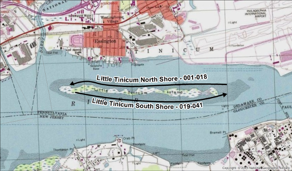
Click an underlined link below
to download a zipped file containing a sequential group of 100 oblique photographs
Photo
#001-043
#001-#019 - LTI North Shore, East to West
#024-#048 - LTI South Shore, West to East
#042, #043 - Upstream views |