Coal Status Report Form
What a Coal Status Report Is:
The California District Office can provide underground mining information to the public in the form of a Coal Status Report. The report may indicate (if information is available); the name and operator of any coal mine underneath the site, the last year that underground mining occurred, the coal seam mined, and depth to the mine from the surface. Information obtain in the report can help homeowners determine the need for Mine Subsidence Insurance. Developers can use the report as a preliminary source of information for construction and/or industrial development projects.
What a Coal Status Report is Not:
A Coal Status Report is for informational purposes only and should not be considered an evaluation or assessment of environmental risks, liabilities, and/or concerns at the site. The information in a Coal Status Report is for the indicated point location only, reports cannot be compiled for large areas, such as entire parcels. Coal Status Reports are for underground coal mining information only, information pertaining to surface coal mines and/or industrial mineral (non-coal) surface and underground mines is available from the applicable DEP District Mining Office for your site. Follow this
link to determine the District Office for your site and its contact information.
How to Request a Coal Status Report:
To request a Coal Status Report, please email
EP-CSR@pa.gov and include a latitude and longitude coordinate point for the site you would like researched, name and company of the requestor, a telephone number to reach the requestor in case there are any questions, and the purpose of the report. Alternatively, you can send in a site location map with a point indicated for the site you would like researched. There is no charge to request a Coal Status Report. It may take up to two weeks to receive a response, but many reports are completed in a faster timeframe.
Description of Coal Status Report forms:
Pennsylvania has two major coal regions; the Bituminous Coal Region in the western part of the state and the Anthracite Coal Region in the Eastern part of the state. There are different Coal Status Reports for the two regions. You will receive the form applicable to the region your site is in.
Coal Status Report – Bituminous Coal Region
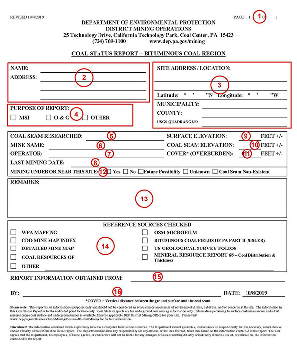
- Number of pages in the report. If there are two or more bituminous coal seams researched for a requested site, then the information for each seam is reported on a different page of the report.
- The name and address of the person requesting the report is placed in the upper left field of the report.
- The location of the site that is being researched is placed in the upper right field of the report. If an exact address is not known, then a general location is given.
- The purpose of the report is indicated. Many requests are for property owners to determine their need for Mine Subsidence Insurance (MSI). Researching Industrial Oil and Gas (O&G) activity sites are also a common purpose to obtain a report. “Other” is indicated for other purposes such as academic research or civil construction/development, or if no purpose is given.
- Each page of the bituminous region report contains information about a different coal seam. The coal seam that was researched is listed here. Some coal seams commonly found in southwest PA include: Pittsburgh, Upper Freeport, Lower Freeport, Upper Kittanning, Middle Kittanning, Lower Kittanning, and Brookville.
- The name of the mine that operated at this site is listed here. If two or more seams have been mined at this site, then it is possible that the mining was done by two or more mines. A mine’s name may also change over the years they are in operation, especially when a mine is bought and sold between operators. The name provided is the most recently documented one available.
- The operator that mined the coal at this site is listed here. Mines may have been operated by different owners through the years. The name provided is the most recently documented one available.
- If the site being researched has been undermined, then the most recent date of mining below the site is noted on the report form. This date may be different than the date the entire mine was closed or the date the mine was sealed.
- The surface elevation is the approximate elevation of the ground surface for the site being researched. This number refers to the number of feet above sea level. This elevation is generally considered to be accurate within twenty feet, however if the site was recently developed, any earth movement at the site may affect this number.
- The coal seam elevation is the approximate elevation of the bottom of the coal seam being researched. This is also measured in feet above sea level. The accuracy of this elevation varies depending on the level of detail found in the mine maps available for this site.
- The cover (overburden) gives the approximate depth (in feet) from the surface to the mine void. This is calculated by subtracting the coal seam elevation from the surface elevation.
- The status of mining at the site being researched is indicated in this section. If "Coal Seam Non- Existent" is indicated, then it could mean the particular coal seam being researched does not exist at the site, therefore mining could not have occurred. If "Future Possibility" is indicated, then it could mean the coal seam is still undisturbed, but there are active mines in the area and the site may one day be undermined.
- If the person researching the site has additional remarks they would like to convey to the requestor, additional information may be included here to further clarify what they found.
- Any reference sources that were checked in the course of researching the site, will be indicated whether or not they actually provided the researcher with any pertinent information.
- The actual file, microfilm card, or book reference where the mining information was actually found is listed on this line.
- The name of the researcher and date the report was completed.
Coal Status Report – Anthracite Coal Region
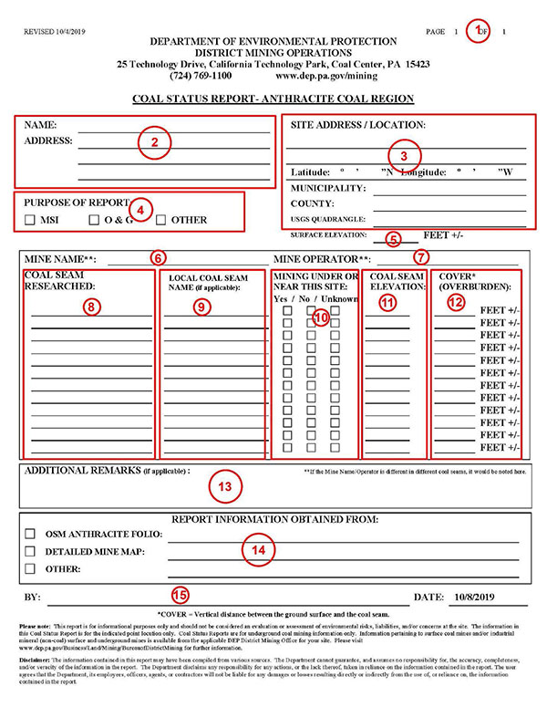
- Number of pages in the report. Usually one page will contain all the information available for a site in the anthracite coal region.
- The name and address of the person requesting the report is placed in the upper left field of the report.
- The location of the site that is being researched is placed in the upper right field of the report. If an exact address is not known, then a general location is given.
- The purpose of the report is indicated. Many requests are for property owners to determine their need for Mine Subsidence Insurance (MSI). Researching Industrial Oil and Gas (O&G) activity sites are also a common purpose to obtain a report. “Other” is indicated for other purposes such as academic research or civil construction/development, or if no purpose is given.
- The surface elevation is the approximate elevation of the ground surface for the site being researched. This number refers to the number of feet above sea level. This elevation is generally considered to be accurate within twenty feet, however if the site was recently developed, any earth movement at the site may affect this number.
- The name of the mine that operated at this site is listed here. A mine’s name may change over the years they are in operation, especially when a mine is bought and sold between operators. The name provided is the most recently documented one available.
- The operator that mined the coal at this site is listed here. Many mines have been operated by different owners through the years. The name provided is the most recently documented one available.
- Many sites in the anthracite coal region have multiple coal seams underneath the site that have been mined. All seams that information is available for will be listed here.
- Many coal seams can be referred to by different names, especially at the local level. If any aliases of a coal seam name are known, they may be listed here.
- The status of mining for each coal seam being researched at the site is indicated in this section.
- The coal seam elevation is the approximate elevation of the bottom of the coal seam being researched. This is also measured in feet above sea level. The accuracy of this elevation varies depending on the level of detail found in the mine maps available for this site.
- The cover (overburden) gives the approximate depth (in feet) from the surface to the mine void. This is calculated by subtracting the coal seam elevation from the surface elevation.
- If the person researching the site has additional remarks they would like to convey to the requestor, additional information may be included here to further clarify what they found. There may be different mines and/or operators that operated on different coal seams under the site, they would be indicated here, if known.
- The reference source, file number, microfilm card, or book reference where the mining information was found is listed on this line.
- The name of the researcher and date the report was completed.
Disclaimer: The information contained in this report may have been compiled from various sources. The Department cannot guarantee, and assumes no responsibility for, the accuracy, completeness, and/or veracity of the information in the report. The Department disclaims any responsibility for any actions, or the lack thereof, taken in reliance on the information contained in the report. The user agrees that the Department, its employees, officers, agents, or contractors will not be liable for any damages or losses resulting directly or indirectly from the use of, or reliance on, the information contained in the report.